
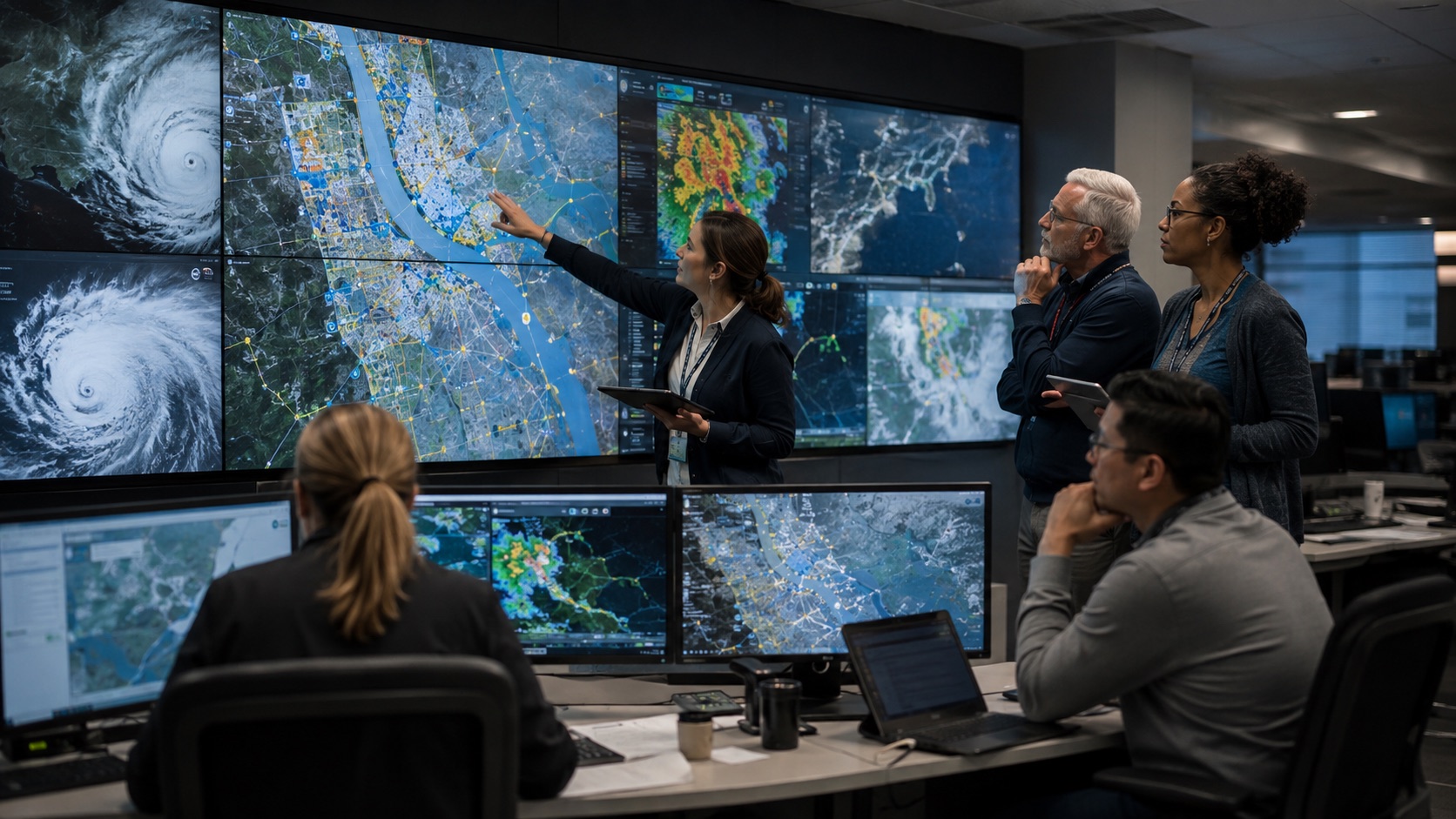
AI can help people understand risk, interpret fast-changing conditions and review damage after a disaster. It cannot remove uncertainty or replace emergency managers, scientists, local authorities or affected communities.
This guide explains where artificial intelligence fits across disaster risk reduction, preparedness, response, recovery and humanitarian action. It also separates realistic capabilities from common exaggerations—especially the false claim that AI can currently predict earthquakes before they happen.
What AI in disaster management means
Disaster management is not a single prediction problem. It is a continuous process of reducing risk, preparing for hazards, responding when events occur and supporting recovery. The United Nations Office for Disaster Risk Reduction (UNDRR) describes disaster risk management as applying policies and strategies to prevent new risk, reduce existing risk and manage residual risk.
Within that process, AI is a set of techniques that can recognize patterns, classify information, estimate probabilities or generate useful outputs from data. If you are new to the subject, start with Artificial Intelligence Explained and Machine Learning Explained.
AI usually works with other technologies rather than replacing them. Satellites and sensors collect observations. Geographic information systems (GIS) organize spatial data. Drones and robots are physical platforms. Computer vision can analyze imagery, while natural language processing (NLP) can help sort text reports. GIS, drones and robotics are not themselves types of AI, although they can incorporate AI systems.
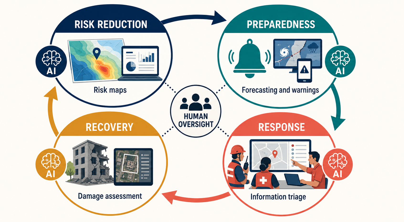
A useful rule: describe the data, the AI task, the operational decision and the responsible human. “Satellite imagery + computer vision + analyst review → a preliminary damage map” is clearer than saying “AI manages the disaster.”
Before a disaster: risk reduction and preparedness
Risk and vulnerability mapping
Machine-learning models can combine historical hazard records, elevation, land cover, infrastructure and demographic information to help identify areas that may face greater exposure or vulnerability. These maps can support land-use planning, evacuation planning and infrastructure inspections. They are estimates, not complete portraits of a community: informal settlements, people without digital records and rapidly changing local conditions may be missing.
Weather, flood and wildfire forecasting
AI-based and hybrid models can support weather forecasting, flood-risk estimation, nowcasting and wildfire risk or spread modeling. They may process observations quickly or reveal patterns across large datasets. The World Meteorological Organization (WMO) emphasizes that AI belongs within a wider forecasting system: observations, physical science, traditional models, operational infrastructure and human expertise remain essential. Official warnings should come from the relevant public authority or national meteorological and hydrological service.
Earthquake prediction, forecasting and early warning are different
AI cannot currently predict a major earthquake by specifying its time, location and magnitude before it begins. The U.S. Geological Survey (USGS) distinguishes three related concepts:
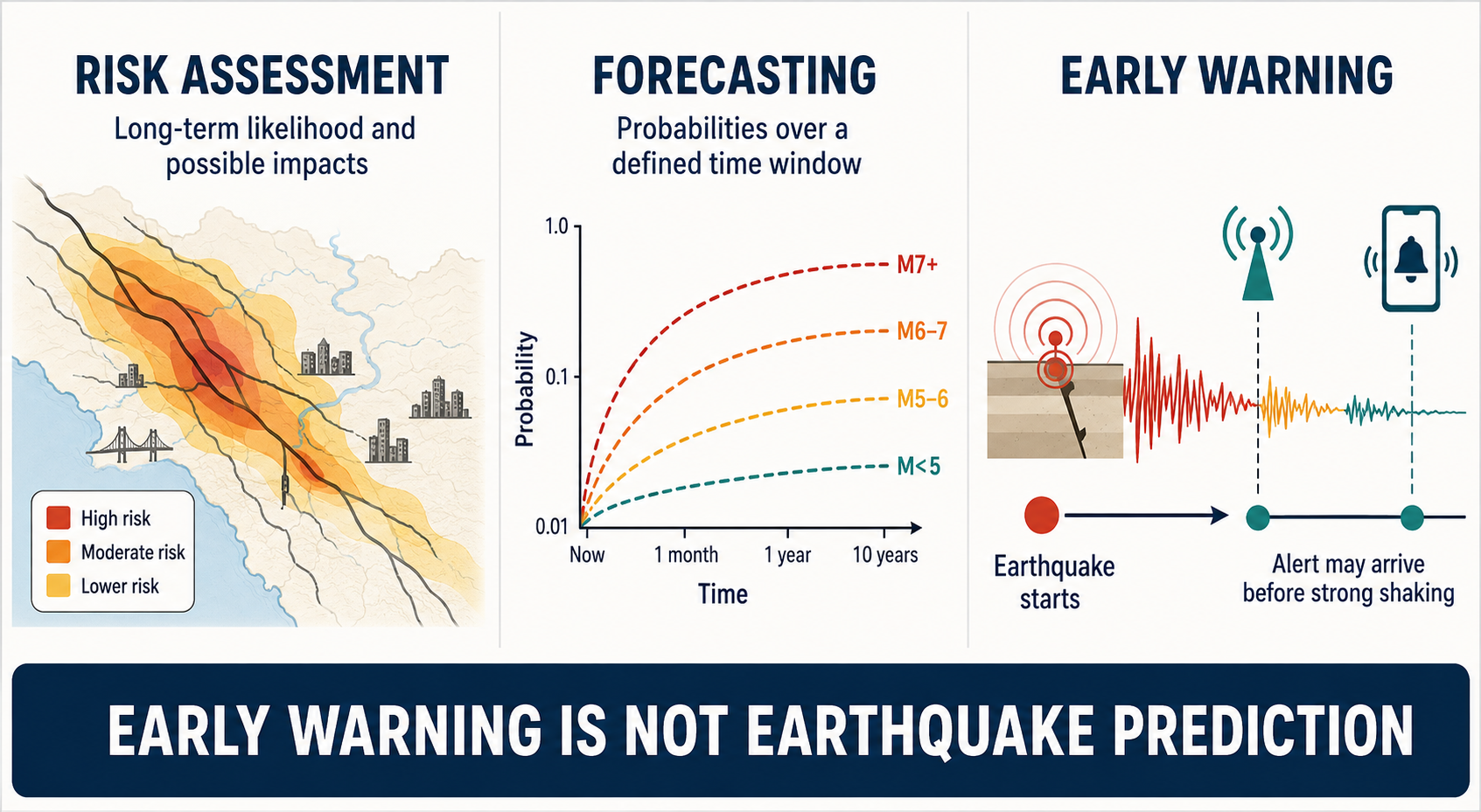
- Earthquake probability and risk assessment estimate longer-term chances and possible impacts using fault, historical and exposure information.
- Earthquake forecasting expresses probabilities over a defined period, commonly for aftershocks following a large earthquake.
- Earthquake early warning detects an earthquake after it has started and may alert locations before damaging shaking reaches them. Depending on distance and system performance, the available warning may be only seconds.
AI may assist with signal detection or rapid estimates inside such systems, but that does not turn early warning into prediction. Alerts also involve tradeoffs: thresholds that reduce missed events can increase false alarms, while stricter thresholds can delay or suppress useful alerts.
During a disaster: response
During response, speed matters, but so do provenance and verification. AI can help teams filter large volumes of information and direct attention to items that need human review.
- Situational awareness: models can combine sensor readings, weather information and imagery to flag changes. A common operating picture still needs timestamps, uncertainty and source labels.
- Imagery triage: computer vision can prioritize satellite or drone images that may show blocked roads, flood extent, fire boundaries or damaged structures. Analysts and field teams must validate results.
- Report classification: NLP can sort incoming text by topic, place or urgency and can support multilingual workflows. Machine translation and automated summaries can lose nuance, so consequential messages require checking.
- Routing and logistics: analytical systems can compare routes, inventories and constraints. Responders must account for road safety, access permissions, local knowledge and people absent from the dataset.
- Search-and-rescue support: drones or robots may carry cameras and sensors into hazardous areas; AI may assist with navigation or image review. These platforms do not replace trained responders or established command procedures.
Social media can provide clues, but it is uneven, noisy and vulnerable to rumors, duplicates and deliberate manipulation. It should not be treated as a representative census of need.
After a disaster: damage assessment and recovery
Post-event imagery is one of the clearest uses of AI. A computer-vision system can compare pre-event and post-event images, segment flooded areas or flag structures that may be damaged. This can help analysts decide where to inspect first. It should not independently determine the true extent of loss, building safety or who receives assistance.
Recovery planners may also use models to compare scenarios for restoring roads, power, water, housing and public services. Models can organize evidence, but recovery priorities involve values and rights as well as efficiency. Community participation, engineering assessment, public accountability and an appeal process remain necessary.
Humanitarian uses—and the do-no-harm requirement
In humanitarian operations, AI may help triage information, translate routine messages, estimate needs or support logistics. These uses can affect people who are displaced, injured or otherwise vulnerable. Data that seems harmless in ordinary circumstances may expose a person’s location, health, identity or relationships during a crisis.
The International Committee of the Red Cross (ICRC) handbook on data protection in humanitarian action examines the risks of AI and automated decision-making in this setting. The practical standard is “do no harm”: collect only necessary data, protect it, limit access and retention, assess possible misuse and preserve meaningful human responsibility.
An optimization model cannot decide what “fair” distribution means. Humanitarian authorities must define priorities, look for missing populations, handle exceptions and provide ways to challenge consequential outcomes. Systems should not infer that people without phones, connectivity, formal addresses or machine-readable records have no needs.
Verified examples
AI as one part of multi-hazard early warning
A 2026 report from UNDRR, WMO, ITU and IFRC assesses AI across risk knowledge, observation and forecasting, warning communication and preparedness. Its central framing is important: AI is an enabling technology whose value depends on observation networks, institutions, governance and human expertise. The report calls for human oversight in life-safety decisions, clear accountability, multilingual and low-connectivity design, and co-design with affected communities.
NASA satellite data and machine learning for severe storms
The NASA Disasters Program has described work using a machine-learning model with geostationary satellite observations to identify cloud-top patterns associated with intense thunderstorms. The output is intended to provide decision-makers with additional information, including in places where ground observations or rapid damage assessments are limited. It is an example of AI-assisted analysis—not a claim that a model controls weather or guarantees a warning.
Operational weather services testing AI
WMO reports that AI-based and hybrid forecasting systems are increasingly used in operational workflows and evaluated alongside physics-based systems. Responsible adoption requires comparisons across regions and events, checks for physical consistency and robustness, and continued authority for national weather services.
Where AI can fail
- Incomplete or biased data: historical records can underrepresent remote areas, informal settlements or groups with less connectivity.
- Distribution shift: a model trained on past events or another region may perform poorly when hazards, infrastructure or climate conditions differ.
- False alarms and misses: both have costs. False alarms can waste resources and erode trust; missed events can leave people unprotected.
- Uncertain outputs presented as facts: probabilities, confidence ranges and known limitations should travel with the result.
- Outages and latency: power, connectivity, sensors or cloud services may fail when they are needed most.
- Automation bias: people may over-trust a confident-looking map or score and disregard contradictory field evidence.
- Privacy and security harm: location, identity or communications data can expose affected people if accessed or repurposed.
A responsible deployment checklist
- Define the decision. State what the system informs and who is accountable.
- Validate locally. Test across relevant hazards, regions, languages and population groups.
- Measure both misses and false alarms. Choose thresholds with emergency professionals and affected communities.
- Show uncertainty and provenance. Preserve timestamps, source information, confidence and known blind spots.
- Keep a trained human in the decision loop. Life-safety warnings and allocation decisions need clear authority and override procedures.
- Minimize and protect data. Apply purpose limitation, access control, retention rules and risk assessment.
- Design for access and equity. Support local languages, disability access and low-connectivity channels; provide non-digital alternatives.
- Plan for failure. Maintain manual fallbacks, redundancy, incident reporting and a process to pause or withdraw the system.
These safeguards connect directly to broader questions covered in our guide to AI ethics and responsible use.
What AI cannot currently do
- Predict the exact time, place and magnitude of a major earthquake before it occurs.
- Guarantee accurate forecasts, warnings or damage classifications.
- Turn incomplete digital traces into a complete picture of community need.
- Replace official warning authorities, emergency command structures or trained field assessment.
- Decide by itself what a fair or humane outcome is.
Frequently asked questions
Can AI predict natural disasters?
There is no single answer for every hazard. AI can support weather and flood forecasting, wildfire risk or spread modeling, impact forecasting and long-term risk assessment. It cannot currently predict major earthquakes by exact time, place and magnitude. Use hazard-specific language and check the authoritative agency responsible for warnings.
How is AI used after a disaster?
Common uses include prioritizing imagery for damage review, mapping possible flood or fire extent, classifying incoming reports, comparing logistics options and supporting recovery scenarios. Important findings should be validated by analysts, engineers, responders and local communities.
Are drones and GIS forms of AI?
No. A drone is an aircraft platform, and GIS is a system for managing and analyzing geographic information. Either may incorporate AI. For example, a drone can collect images, computer vision can flag possible damage and GIS can display the reviewed results on a map.
Knowledge check
1. What is earthquake early warning?
A notification generated after an earthquake has begun but before strong shaking reaches some locations. It is not earthquake prediction.
2. Which description is accurate: “GIS is AI” or “GIS can incorporate AI-assisted analysis”?
“GIS can incorporate AI-assisted analysis.” GIS is a geospatial information technology, not an AI technique.
3. Why must teams measure both false alarms and missed events?
Because lowering one type of error can increase the other. Both carry operational and human costs, so thresholds must match the hazard and decision context.
4. What role should AI play in humanitarian resource allocation?
Decision support. Humanitarian authorities remain responsible for priorities, missing populations, exceptions, fairness and consequential decisions.
Continue learning
Explore more real-world applications of AI, including AI in environmental science and AI in education. The most useful question is not whether AI is present, but what evidence it adds, what it can miss and who remains accountable.